


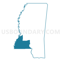
Southwest Region PUMA, Mississippi
About
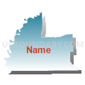
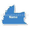
Outline

Summary
| Unique Area Identifier | 193266 |
| Name | Southwest Region PUMA |
| State | Mississippi |
| Area (square miles) | 5,341.19 |
| Land Area (square miles) | 5,271.47 |
| Water Area (square miles) | 69.71 |
| % of Land Area | 98.69 |
| % of Water Area | 1.31 |
| Latitude of the Internal Point | 31.43863060 |
| Longtitude of the Internal Point | -90.78283710 |
Maps

Graphs
Select a template below for downloading or customizing gragh for Southwest Region PUMA, Mississippi


Neighbors
Neighoring Public Use Microdata Area (by Name) Neighboring Public Use Microdata Area on the Map
- Capital Region Planning Commission 1--Baton Rouge Metropolitan Area (West) PUMA, LA
- Capital Region Planning Commission 6--Livingston & St. Helena Parishes PUMA, LA
- Capital Region Planning Commission 7--Tangipahoa & Washington Parishes PUMA, LA
- Central Region--Hinds (West), Warren & Copiah Counties--Vicksburg City PUMA, MS
- Central Region--Rankin & Simpson Counties PUMA, MS
- Kisatchie Delta Regional Planning & Development District 1 PUMA, LA
- North Delta Regional Planning & Development District 2--Northeast Louisiana PUMA, LA
- South Region--Forrest, Lamar, Marion & Perry Counties--Hattiesburg City PUMA, MS
- South Region--Jones, Wayne, Covington, Greene & Jefferson Davis Counties PUMA, MS
Top 10 Neighboring County (by Population) Neighboring County on the Map
- Hinds County, MS (245,285)
- Tangipahoa Parish, LA (121,097)
- Warren County, MS (48,773)
- Washington Parish, LA (47,168)
- Pike County, MS (40,404)
- Lincoln County, MS (34,869)
- Adams County, MS (32,297)
- Copiah County, MS (29,449)
- Simpson County, MS (27,503)
- Marion County, MS (27,088)
Top 10 Neighboring County Subdivision (by Population) Neighboring County Subdivision on the Map
- District 2, Hinds County, MS (43,374)
- District 5, Warren County, MS (11,330)
- District 1, Tangipahoa Parish, LA (10,722)
- District 4, Warren County, MS (10,169)
- District 3, Pike County, MS (9,025)
- District 4, Pike County, MS (8,574)
- District 7, Washington Parish, LA (8,562)
- District 5, Washington Parish, LA (8,290)
- District 4, Lincoln County, MS (8,200)
- District 5, Adams County, MS (7,957)
Top 10 Neighboring Place (by Population) Neighboring Place on the Map
- Natchez city, MS (15,792)
- McComb city, MS (12,790)
- Brookhaven city, MS (12,513)
- Magnolia city, MS (2,420)
- Wesson town, MS (1,925)
- Summit town, MS (1,705)
- Centreville town, MS (1,684)
- Fayette city, MS (1,614)
- Tylertown town, MS (1,609)
- Monticello town, MS (1,571)
Top 10 Neighboring Unified School District (by Population) Neighboring Unified School District on the Map
- Tangipahoa Parish School District, LA (121,097)
- Vicksburg Warren School District, MS (48,773)
- Hinds County School District, MS (46,830)
- Washington Parish School District, LA (34,936)
- Natchez-Adams School District, MS (32,297)
- Simpson County School District, MS (27,503)
- Concordia Parish School District, LA (20,822)
- East Feliciana Parish School District, LA (20,267)
- Brookhaven School District, MS (18,623)
- Copiah County School District, MS (18,369)
Top 10 Neighboring State Legislative District Lower Chamber (by Population) Neighboring State Legislative District Lower Chamber on the Map
- State House District 74, LA (55,721)
- State House District 75, LA (44,623)
- State House District 72, LA (43,119)
- State House District 18, LA (41,706)
- State House District 21, LA (38,614)
- State House District 62, MS (28,658)
- State House District 99, MS (26,927)
- State House District 92, MS (26,069)
- State House District 100, MS (25,804)
- State House District 97, MS (25,156)
Top 10 Neighboring State Legislative District Upper Chamber (by Population) Neighboring State Legislative District Upper Chamber on the Map
- State Senate District 12, LA (136,047)
- State Senate District 17, LA (122,268)
- State Senate District 32, LA (111,685)
- State Senate District 34, LA (101,227)
- State Senate District 40, MS (62,702)
- State Senate District 41, MS (56,638)
- State Senate District 39, MS (56,401)
- State Senate District 37, MS (55,722)
- State Senate District 38, MS (52,716)
- State Senate District 23, MS (51,680)
Top 10 Neighboring 111th Congressional District (by Population) Neighboring 111th Congressional District on the Map
- Congressional District 3, MS (756,924)
- Congressional District 4, MS (754,015)
- Congressional District 6, LA (727,498)
- Congressional District 1, LA (686,961)
- Congressional District 2, MS (668,263)
- Congressional District 5, LA (644,296)
Top 10 Neighboring Census Tract (by Population) Neighboring Census Tract on the Map
- Census Tract 9517.01, West Feliciana Parish, LA (8,272)
- Census Tract 9504, Simpson County, MS (7,759)
- Census Tract 1, Adams County, MS (7,602)
- Census Tract 9501, Walthall County, MS (7,063)
- Census Tract 9506, Pike County, MS (7,014)
- Census Tract 9503, Lincoln County, MS (6,947)
- Census Tract 9505, Pike County, MS (6,724)
- Census Tract 9503, Walthall County, MS (6,680)
- Census Tract 9504, Lincoln County, MS (6,616)
- Census Tract 9502, Lincoln County, MS (6,201)
Top 10 Neighboring 5-Digit ZIP Code Tabulation Area (by Population) Neighboring 5-Digit ZIP Code Tabulation Area on the Map
- 39180, MS (32,603)
- 39120, MS (32,334)
- 39601, MS (23,536)
- 39648, MS (21,710)
- 70438, LA (18,540)
- 39429, MS (17,657)
- 70775, LA (14,720)
- 39667, MS (12,837)
- 39083, MS (10,626)
- 70444, LA (10,160)